Baron Weather is proud to share that it has earned the Esri State and Local Government Specialty, formally recognizing Baron’s proven expertise in delivering mission-critical, GIS-ready weather intelligence for public sector agencies. Baron Weather is currently the only weather content partner to receive this Esri specialty.
The Esri Partner Specialty Program recognizes partners who demonstrate deep technical expertise, successful ArcGIS deployments, and an ongoing commitment to customer success. Industry-focused specialties help government organizations identify partners with validated experience supporting their unique operational needs. Earning the State and Local Government Specialty reinforces Baron Weather’s role as a trusted provider of real-time weather intelligence that integrates seamlessly into Esri workflows.
This recognition further strengthens Baron Weather’s alignment with Esri. Baron’s participation in Esri’s Disaster Response Program (DRP), combined with the newly awarded specialty, reflects a shared commitment to supporting state and local agencies before, during, and after extreme weather events. Together, Baron and Esri help emergency managers, GIS teams, and public safety officials integrate authoritative weather intelligence directly into ArcGIS, Esri's comprehensive geospatial platform to support operational decision-making when it matters most.
“Earning Esri’s State and Local Government Specialty reflects the strong alignment between Baron Weather and Esri, and our shared commitment to supporting government agencies when it matters most. By delivering real-time, GIS-ready weather intelligence directly into Esri workflows, we’re helping emergency managers and decision-makers act faster, improve situational awareness, and strengthen resilience before, during, and after extreme weather events.”
Baron Weather provides state and local government customers with high-resolution, real-time weather data integrated into ArcGIS tools designed to support emergency operations and public safety workflows. During rapidly evolving events, Baron’s solutions deliver actionable insights that help agencies monitor conditions, issue timely alerts, and respond with greater confidence when lives, property, and critical infrastructure are at risk.
Alerting plays a critical role in these workflows. Baron Weather’s real-time weather intelligence supports event-driven awareness and automated notifications when integrated with capabilities such as ArcGIS Velocity, enabling agencies to detect hazards sooner, streamline response coordination, and reduce manual monitoring during high-impact events.
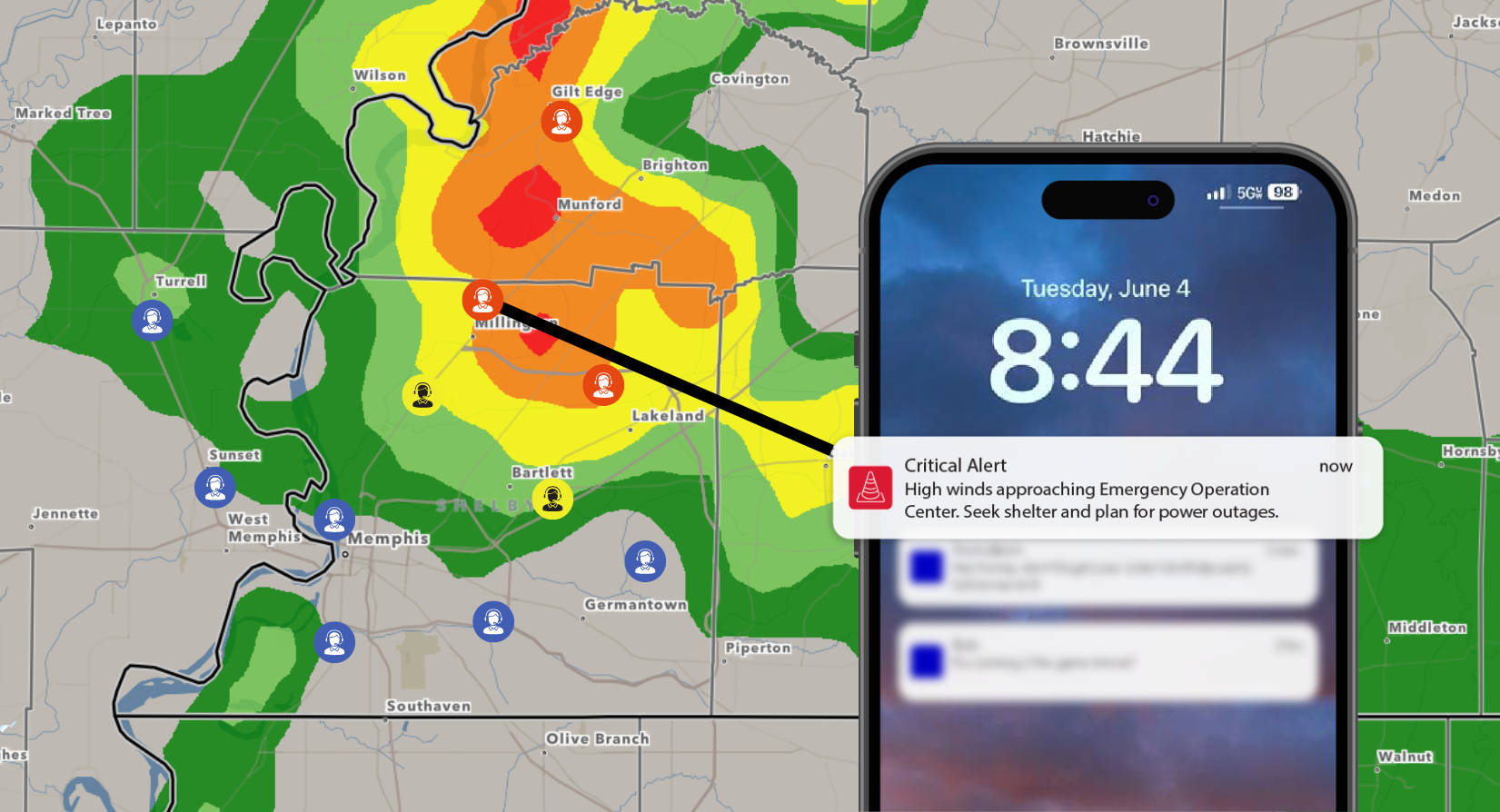
The Esri State and Local Government Specialty formally validates Baron Weather’s experience delivering mission-critical weather intelligence tailored to the needs of public sector users. Baron’s strong focus on real-time data, alerting, and GIS-ready applications aligns closely with government use cases, supporting faster decisions, improved situational awareness, and more resilient communities.
To learn more about Baron Weather’s GIS-integrated weather solutions for state and local government, including Esri-ready data, real-time alerting, and operational workflows, click here.
